AGLAG BUTEEL MONASTERY

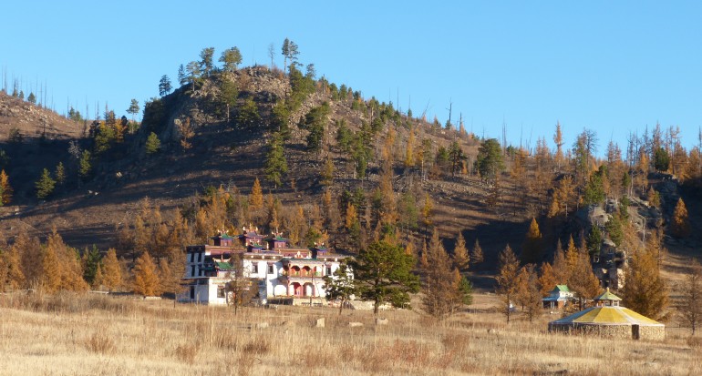
The monastery located in 16 km west from Bornuur soum of Tuv province, at the front of Dalyn Khavtsal Mountain. Created by Buddhist artist and lama G.Purevbat to practice meditation, to educate and create books. The monastery gate protected by Garuda griffin, which is laying its 8 eggs and a beaver with fish head to guarding. The paradise monastery and Buddha portrait exalted in the position on honor, Yanjinlkhama goddess on the right wall, and the paradise and the hell paintings on the left wall. There is a gecko and Scorpion statues on the gigantic stone in the monastery. What's more, there is a road with special vacuum environment for meditation, blessing and anyone, who walk by this road able to understand human and natural linkage, to care for the earth, and to purify their spirit and mind.
ALTAI TAVAN BOGD (MONGOL ALTAI RANGE)

This huge mountain range is
over 900 km long stretching from western end of the
country passing through Gobi-Altai Aimag. The highest peak is 4374 m high Mount Khuiten. This 100km-long mountain
range starting from Mount Khuiten to Gichgenii Nuruu is known as Altai range.
There are glaciers at the height of 3500-4000m of the mountain range. The
biggest one is 20km-long Potanin glacier, at the beginning of Tsagaan River.
Altai range has 5 main peaks which are Khuiten (4374m), Nairamdal (4082m), Malchin (4037m),
Burged (4068m) and Ulgii (4050m). Total of over 650 mountaineers has reached
the mountain peak since the first mountaineer in 1956.
ALTAN OVOO (DARI OVOO)

(Ovoo - cairn - like pile of rocks)
This place is also known as
“Dari Ovoo”. It is one of the volcanoes in Dariganga Soum,
Sukhbaatar Aimag and is located 1354m above sea level. Locating near the center
of Dariganga Soum, this mountain is a main worship of the locals inhabiting on
the southern part Sukhbaatar Aimag. It was being worshipped by the locals until
the early 20th century when Bogd Khaan Jibzundamba, a former
theocratic and political leader of Mongolia, had this cairn official worshipped
mountain. Worshipping practice was halted during the socialist regime, but
revived again in 1990. In 2004 it became a state worshipped mountain and a
pinnacle atop of the cairn was gilded completely.
Golden Cairn is one of the
“men only” pilgrimage sites. One who reached the summit is expected to fume a
juniper and pour a libation to the spirit of the land. Women are strictly
prohibited to climb the cairn; instead they climb a small cairn southwest of it
or go clockwise round it along a particular road. Golden Cairn has a
crater flowing northwest. There are Lake Duut on the west and Mount Shiliin
Bogd on the east. Main tree on the cairn is known as Sorogshin Tree which is
supposed to have been brought from Mount Otgontenger. In order to bring the
tree, tea and food samples were offered to calm spirit of the land and water.
Sorogshin Tree must be ever green fruity tree and in our country Siberian pine
refers to this special tree. It is over 300 years since Sorogshin Tree brought
to the cairn without reaching the ground.
AMARBAYASGALANT MONASTERY

(Translates
as “peaceful happiness”)
Amarbayasgalant
Khiid or the Monastery of Tranquil Felicity - once one of the three
largest Buddhist institutions in Mongolia is located near the Selenge river in
the Iven river valley, at the foot of Mount Buren-Khaan in Baruuburen soum of Selenge
province in northern Mongolia. Looking for a site for building, the exploratory
group met a boy and a girl, Amar and Bayasgalant, playing in a steppe, and
decided to build the future monastery at that site and name the monastery after
those children. The Amarbayasgalant Monastery was built
to honor the memory of theocratic leader G.Zanabazar, by order
Manchu Emperor Enkh-Amgalan Khan (Yongzheng).
G.Zanabazar
(1635 – 1723) Zanabazar
was the son of the Tusheet Khan, one of the rulers of seventeenth-century
Mongolia, and a distant descendant of Genghis Khan, founder of the Mongol
Empire. His spiritual propensities were apparent almost from birth and in 1639,
while still a little boy; he was recognized as the head of the Sakya sect of
Buddhism in Mongolia. He later traveled to Tibet where he was recognized as the
16th incarnation of Javsandamba and converted to the Gelug sect of Tibetan
Buddhism by the 5th Dalai Lama. As the head of the Gelug sect in Mongolia he
introduced many new innovations, including the Maitreya Ceremony, and initiated
the construction of numerous new temples and monasteries. A renowned polymath,
Zanabazar composed new prayers, scriptures, and music, and invented the Soyombo
alphabet, but he is probably best known for his incomparable sculptures, which
rank among the greatest works of Buddhist art ever created. These include White
Tara, the Twenty-One Taras, the five Transcendental Buddhas, Sitasamara,
Vajradhara, and many more.
The
Monastery was built between 1726 and 1737 using imported craftsmen; the
overall style is Chinese, despite some Mongol and Tibetan influence. The
monastery is certainly different and more unitary than any other in Mongolia.
The main temple was constructed without single iron nail and all based on
wooden block puzzles. Surrounded by a wall, the buildings are set in a
north-south axis around the main two-storey Tsogchin Dugan, or
main temple. Pavilions, courtyard and smaller temples are set methodically
around the grounds. By the early 1890s, Amarbayasgalant was one of the most
important pilgrimage sites in Mongolia. In the early 1900s, over 8,000 monks
lived at the monastery. During
the anti-Buddhist purges of the 1930s, many of Amarbayasgalant’s temples were
ransacked of their relics and several buildings destroyed. But the main temple
complex was not destroyed and restoration work began in 1988 and some of the
new deities were commissioned in Delhi, India. Finally reopened as a fully
functioning monastery in 1991. The pilgrims have returned and the monastery is
again the site of important Buddhist gatherings.
AURAG ORD (PALACE OF AURAG)

Palace of Aurag, an ancient city ruin beneath the surface of the earth, is situated north of Rashaan Dersnii Ukhaa and south from the “Avarga toson” spa-resort in Delgerkhaan Soum, Khentii Aimag. It is supposed that the name of the city ruin was originally “Aurag”, and later changed into “Avarga”. Researchers claim the meaning of the word “aurag” is not huge, enormous or great, but cave or warehouse.
During the 13th century
there was a need of warehouse to keep food and articles of tribute from the
countries under control of the Mongol Empire. Therefore, they established this
city where the most of the royal courts were built in, and named it “Aurag”.
This place is supposed to be the city that had been serving as a capital of the
empire and Mongol tribes for over 30 years since 1189. As a result of the
excavation, it became clear that the city had four distinctive parts covering
4.5 sq km area. There was a district of farming on the eastern part of the city
and temple worship placed on the special porch surrounded by double fortress on
the northern part from the central area. The temple foundation was 180 sq m and
the number of columns on it was over 40. Polished 6-sided stone column was
found in the front section of the porch. Particular wall fortresses were placed
in row east to west on the western part of the city.
Building remains of 13
fortresses each with 3-4 small buildings inside were revealed here. After
digging many finds were found including a potsherd, a plough-share, artifacts
of iron, bone and mud, iron smelting blast furnace, cast iron, and a hone stone.
BAGA GAZRYN CHULUU

Hunnu Graves: Possible to see 64 Hunnu graves at once in Dund Shandyn Am of Baga Gazryn Chuluu. In 1989 Mongolia-Hungary-Russia joint group excavated the area. Distances between the graves vary and a depth of the grave hole is 3.3m. During the excavation many articles were found including a curved ends of a bow, an iron bridle bit and a broken rippled vase ext.


BAGA GAZRYN CHULUU

Situated about 37km northwest from the centre of Delgertsogt Soum,
Dundgobi Aimag. This area of granite surrounded by flat plains is
located 1768m above sea level covering 300 sq km area. Around the mountain pass
and valley one can see considerable number of ancient graves, khirigsuurs,
petroglyphs and monuments besides many gushing springs. There are many sights
to see such as a rocky ravine of poplar called Sudutyn am, Jargalant cave,
spring of eyesight, Tahilgiin Havtsal. (Tahilga canyon), Ger Chuluu and Hunnu graves.
Ger Chuluu: It contains many cave drawings including a petro glyph depicted a
man tying 2 ibex with a rope. This cave painting belongs to the latter period
of Bronze Age and attracts greater attention from researchers. On a nearby rock
2 deer were depicted at their real size. One of them is 170cm long and 90cm
high.
Sudutyn Am: This mountain gap was named as Sudutyn Am, because large amount of
grass called sud grow in the area. About 300 years ago 2 monks lived as a
hermit among poplar groves in this rocky canyon. They erected their home in the
area where a brook flows through. So, they could take water inside their home
without going out. These monks were entombed here with their creations.
Currently, an entrance of the canyon is closed with a fortress. Later in the
early 20th century this canyon was being used by Zava Damdin, a
well-known representative of Mongolian yellow sect Buddhism, to create his
works.
Jargalant Cave: This 18m-long cave is situated 1km from Sudutyn Am. While going
through the cave, one is forced to cover first half of the way on foot but
another half by crawling. In ancient time there were crystal-like glittering
water drops along the cave wall. Unfortunately, currently there are almost any
of them.
Springs of eyesight: Springs of eyesight is 1km from both Sudutyn Am and Jargalant Cave.
The spring is in 50cm-deep and 7cm-diametered hole. It is believed that one’s
eyesight will improve if this spring is applied to his or her eyes by using
special dipper hung nearby.
Takhilgyn Khavtsal: Being 1768m above sea level Takhilgyn Khavtsal is the highest peak
of the Baga Gazryn Chuluu. The mountain has a high rocky ravine making a sight
extremely grand. Occasionally, ibex and mountain sheep appear here.
Hunnu Graves: Possible to see 64 Hunnu graves at once in Dund Shandyn Am of Baga Gazryn Chuluu. In 1989 Mongolia-Hungary-Russia joint group excavated the area. Distances between the graves vary and a depth of the grave hole is 3.3m. During the excavation many articles were found including a curved ends of a bow, an iron bridle bit and a broken rippled vase ext.
BALDAN BEREEVEN MONASTERY
(Or
Baldan Baraivun Monastery, “Baraivun” translates as “rice boiling over”)
Baldan
Baraivun Monastery – had been the second largest Buddhist institution in
Mongolia -is situated in the front side of Mount Munkh-Ulziit in Umnodelger
soum of Khentii province in the eastern part of Mongolia,
300 kilometers from Ulaanbaatar city. At
the end of the 17th century, the Khan of Mongolia invited Lama Tseweendorj to
his court and asked him to build the monastery Baraivun somewhere in the east.
Searching
for a suitable place for the monastery, Lama Tseweendorj arrived at a pleasant
valley to the south of the Delgerhaan mountain range in what is now the Khentii
Province. There at the foot of Mount Munkh-Ulziit, he found a poor family's
camp. Lama Tseweendorj met an old couple, named Baldan and Zepelmaa, who invited
him into their ger. As he entered the old couple’s home he was greeted with the
auspicious sign of a pot of rice boiling over on the fire. The Lama
took some of the rice. He immediately understood that the rice and the
significant names of the old couple were auspicious signs. He therefore
selected this as the place where the monastery would be built. In addition to
the rice, they noticed that the mountains surrounding the valley in each of the
four cardinal directions resembled important Buddhist protector deities. The construction of Baldan Baraivun
began with the erection of a small yellow temple built of local materials. A
statue of the god Manzushir, carved from a huge stone by the Lama Tseweendorj
himself, was placed at the center of the temple. Construction continued with
four storeys building of the main temple "Tsogchin Dugan" and named
“Bileg –Ulziit” near the first temple. The ground floor alone contained 64
angular pillars and was accessed through three different gates facing east,
south, and west. Religious flags were hung at each corner and the roof
ridge was richly decorated with gold plated Buddhist symbols such as Soyombo,
Mirrors, Dug, Jantsan, Horol, and the holy antelopes. The next building constructed was the
theological department which included sections for astrology, philosophy, and
medicine. The monastery soon became one of the most important Buddhist centers
in Mongolia, inhabited by 5000-6000 monks. It took nearly 76 years to complete
the building construction, was started in 1700s and finished around 1776. For
centuries the Baldan Baraivun monastery was famous throughout the "Ar
Halha" region for its many scholars, lamas, artwork, and cultural
treasures. Behind the monastery special formation of rock which is called
womb symbolizing rebirth.
Between
1937 and 1939, religious persecution became common and a political opposition
began to form. Almost all monasteries, like Baldan Baraivun, have been
destroyed. At Baldan Baraivan, "The Yellow Temple," the entire
surroundings were destroyed and only the ruins of the buildings remain. For over 60 years it was forbidden to visit
the monastery. In 1990s a
democracy in Mongolia, a number of monks reestablished some part of the monastery
with the locals. The surrounding rocks of the monastery have been remained with its
religious carvings which prove the history of that time.
BIIBULAGYN RUIN (BAIBALIK CITY)

Uighar city ruin Baibalik is situated 14km west from the centre of
Khutag-Undur Soum, Bulgan Aimag and locals also call it
Biibulag. 44th line of an inscription on the stele which
is built in Saikhan Soum, Bulgan Aimag dedicating to Uighar king Myunchur says
that “I ordered to establish Baibalik city on bank of Selenge River”.
Therefore, researchers claim that this city was built by Myunchur, a king of
Uighar. Since its establishment, the city had always been visited by Sogd
(current Tadjigistans) and Chinese merchants, Sogd preachers.
They did a missionary work and translated Buddhist writings into
Uighar language. Baibalik was a flourishing city and one of cultural centers in
central Asia of the period. There were two fortresses built of clay in the
city. But most part of them collapsed and only east and north
section of the northern fortress remained currently. This remained fortress is
4m high and 2m thick. Many tiny holes on the fortress are supposed to have been
used for observing outside. On northern fortress of the city there was a large
temple surrounded by lions of male and female. In 840 Baibalik city was
destroyed by Kirgiz nomadic tribes from Yenisei River. All books and sutras
were burned during this destruction.
BILGE KHAN AND GENERAL KUL TIGIN COMPLEX (KHUSHUU TSAIDAM MEMORIAL COMPLEX)

This sacred memorial complex
dedicated to Bilge khan of Turkic empire, which flourished during the 6th-8th century,
and his younger brother Kul Tigin is situated 40km northeast from Karakorum and
20km east from Ordubalik in Khashaat Soum, Arkhangai Aimag. Kul Tigin’s
grandson, Iolug Tegin, had this memorial built. Bilge khan’s stele, well known
as Orkhon Inscription, is 3,3m high, 1,3m wide and has 68 rows of inscription.
Bilge khan, who was the latest king of Turkic empire, ruled its country for 19
years. During the excavation of the memorial in 31th of July,
2001, over 2000 finds were revealed and the most important one among them was a
gemstone inlaid golden crown of Bilge khan. It was formerly an entire complex,
but only this stele has been remained currently. There are over 40 runic stelae
in Mongolia and about 10 of them are located only in the Orkhon Valley; that is
why it was named Orkhon Inscription. A trace of square burial protected by a
parapet wall was in the complex. But this burial is considered to be an
artificial one without a real human corpse which had a symbolic
meaning. Fragment of tiled roof with an image of nomads shooting
each other while galloping was found from the site. These 2 stelae of Bilge
khan and Kul Tigin are 1km apart from each other. These memorials were
recognized as a “cultural landscape” of the UNESCO World Heritage in 1996,
although they had been destroyed much throughout its history of over thousand
years. Mongolia announced 20.8 sq km area around the complex as a zone under
state protection in 1961. Ulaanbaatar, a capital of Mongolia, was once located
in the area when its name was Shar Bust Urguu and it had settled here for about
14 years since moved from Lake Shireet Tsagaan.
This monument of Kul-tegin (Kul Tigin), a famous general of Tureg,
is situated on right bank of Orkhon River in a valley of Lake Tsaidam 60km
north from Karakorum in Khashaat Soum, Arkhangai Aimag. The steles in this
complex have been being explored for over hundred years. In 1958 Mongol-Czechoslovakian
joint research group excavated the complex completely. Kul-Tegin, a general of Tureg (A.D. 552-745), was born in 684.
This intelligent, capable general had devoted himself to state affairs since he
was only 16. In 732, after his death in 731 at the age of 46, Bilge king had
this sacrifice complex and a temple of worship established. The sacred complex
was protected by a 1m-thick bricked fortress surrounded by a moat enclosing 67m
long, 29m wide area. Empty space inside the fortress was filled with bricks of
32x32x6cm size. Many finds including mud vase, artifacts and adornments of
iron, a roof fragment, a dustpan and a vase were found from the complex. The
monuments realistically represent appearance, clothing, utensils and adornments
of people of that period.
BINDER OVOO (BINDER CAIRN)

Situated in Batshireet Soum, Khentii Aimag this cairn of rock is located on a special establishment built of a Shurgaag tree. On the southeast of the cairn there is Rashaan Khad covered with various kind of stamp marks and ancient petro glyphs. These distinctive stamp marks and cave drawings each belong to a different period of history. Drawings on the rock include ancient animals like a first mammal rhino, a lion, the most long lived huge mammal and an elephant. These drawings proved that ancient people living around the Khentii range 40000-14000 years ago had been living by hunting these animals.
BUGIIN TSAV

Situated 50km north from Khermen Tsav in Bulgan Soum, Umnugobi Aimag. The area is rich of fossilized dinosaur finds. Fossils of many different species like dinosaurs, a turtle, a fish and a mollusk along with interesting traces showing their lifestyle lie around the ground everywhere and it really catches researchers’ as well as people’s interest. Skeleton of carnivorous Tarbosaurus found in the area is now being kept as a show in the Museum of Natural History. Bugiin Tsav is a special protected area in the zone of natural complex area called “Gobi Gurvan Saikhan”.
CHIN TOLGOIN BALGAS

This ancient city ruin is situated in a sunny side of a small hill Chin Khairkhan 16km east from Dashinchilen Soum, Bulgan Aimag. The ruin consists of a watchtower on hilltop, a fortress ruin and abandoned sites of a yurt outside the fortress. There is a currently 10m-high watchtower on northwest of the fortress and it was made of granite and dark grey siliceous rock. From the watchtower 20-30km area can be seen. There are also ancient stele’s base and 2 large stone turtles. Several roof-tiles inscribed in Khitan and furnace remains of approximately 1000 households were found around the fortress. As a result of the research, it became clear that this is a ruin of Chjen Chjou, a city of Khitan. A Chinese monk Chani Chun Bumba who traveled through the site in the 13th century on the way to Genghis khan recorded that it was a ruin of Chjen Chjou city of Khitan and also he said there were three other Khitan city ruins west from Tuul River. Khadaasangyn or Khar Bukhyn Balgas is on the west and Talyn Ulaan Balgas is on the right side of Chin Tolgoin Balgas. All of them date back to the same period. According to the sutra, this city was being inhabited by about 20,000 soldiers of northwest tribe of Khitan and over 700 Chinese and Zurchid families who had been exiled to the city. Researchers regard that establishment of the city started during the Uighar period and expanded during the Khitan period. Later, during the period of Prince Tsogt, it had been used as a military camp and a watchtower. This is a unique architectural example because the fortress was built of conglomerate. The watchtower is supposed to have been 30m high with a base of 40m in diameter. It was built of rocks and stones carried from a mountain. Chin Tolgoyn Balgas was taken under state protection in 1998.
CHINGGISYN DALAN

This 500-600km-long earth fortress stretches from west of old center of Baruun-Adarga Soum, Khentii Aimag passing north of Lake Sain Tsagaan through Norovlin Soum, Bayandun Soum, Dornod Aimag and Khermyn Khudag in a terrain of 3 Soums, Tsagaan-Ovoo, Sergelen, Gurvanzagal. It discontinues at several parts and only some parts or 300km of the fortress is in a Mongolian territory. There are some small earth fortresses measuring 40m x 50m where guards had been sitting in.
For instance, Durvuljin Buudal, Ulzyn Undur Dovyn Kherem, Mogoyn Adgiin Kherem, Uguumeryn Kherem, Delgerekhyn Tal and Bayanbulagiin Kherem. It is said that it takes midday or a whole day to travel between each fortress. Some of them are 8-12km apart from each other. There were no traces that someone had been living in the fortress, but vase and bowl remains were found. Fortresses like them are said to have found in large numbers along Chinggisyn Dalan. It is also said that fortresses of midday are triangular and fortresses of whole day are square. In southern Mongolia there are also places like it. For example, in Nomgon Soum, Khurmen Soum, Bayandalay Soum and Noyon Soum of Umnugobi Aimag, there is a long earth fortress also called Chinggsiyn Dalan. Researchers suppose that these fortresses as were a border of any foreign country. But, it hasn’t been researched thoroughly until today.
CHOIR MONASTERY

Large
number of Buddhist monasteries and temples was built throughout all over the
Mongolian territory between 1600 and 1800s.
In
the eastern Mongolia, in 1779 there was set an establishment of one important
and powerful monastery. At the beginning, the monastery’s name was
“Baldandashgomlin” as Tibetan. During Buddhism flourishing time in
Mongolia, this monastery played main role in preparing religious staff,
especially high educated lamas in foreign languages as Tibetan, Indian and
Sanskrit and science of astrology. Philosophical creatures of Buddhism,
poetries were translated in the temple from mentioned languages and spread
though.
It
marked out for monastery’s capacity and how big it was, nearly 1500
inhabitation of Buddhist lamas and 5-7 religious schools and faculties like
“Choir”, “Djud”, “Mamba”, “Duinhor” and etc. Noted handicraftsmen and merchants
lived there, except only lamas. Additionally, more than 500 monasteries of the
700 Mongolian monasteries have had their own local variations of the ceremony.
“Zahra” and ‘Duinhor” tsam dance - the most popular religious mask dance were played
and the biggest celebration of Buddhism “Maidar Ergekh” was held in the Choir
monastery, too.
The
monastery’s leaders were high mental potential Lamas. The 5th leader
was Lama Gonchigdambil, once his camp was on a fire and burnt to the ground but
amazingly only single thing was found from camp ashes without any harm. That
was the fifth leader’s portrait drawn by him. The portrait has been kept in the
Gandan Monastery, present Mongolian biggest Buddhist center.
Between
1937 and 1939, religious persecution became common and a political opposition
began to form. Almost all monasteries and temples have destroyed. In 1938, this
black wind knocked down and set the monastery on a fire, just left the ruin
nothing else.
The
Ruin of Choir Monastery was taken into Mongolian State protection in 1993.
CHULUUT RIVER

Chuluut River in Undur-Ulaan
Soum, Arkhangai Aimag takes its rise from Eg mountain pass of Khangai range and
after flowing for about 415km it forms Selenge by joining Delger River and Ider
River. Chuluut River flows through 20m-deep steep canyon of basaltic rock for
about 100km from the river-mouth of Teel River till Atsat River. A basaltic
rock is magma flew from the Mount Khorgo and other volcanoes near it. There is
a small waterfall flowing down from a steep rock near a confluence of Suman and
Chuluut rivers. This waterfall is known as Choidogyn Borgio and it is
interesting to see fish gathered from Chuluut and Selenge rivers flashing the
surface upwards waterfall. Chuluut River canyon is rich of springs abundant in hydro
carbonate, sulfate and sodium, and contains many petro glyphs date back to
Neolithic and Bronze Age. These cave paintings include unique depictions such
as images of 6 women giving a birth, a man shooting with a bow and an arrow,
herds of ibex and deer, a man standing with raised hands, oxen, mountain sheep,
profiled paintings of men and a masked man. These paintings were taken under
state protection in 1998.
DADAL MONUMENT (MONUMENT OF GENGHIS KHAN)

This monument was erected near Gurvan Nuur
tourist camp in Dadal Soum, Khentii Aimag in 1962 celebrating 800 years’ birth
anniversary of Genghis khan. This 12m high, 4m thick and 10m-based monument was
designed by a sculpture L.Makhval. Atop of the monument, a fire image burning
like a lotus was placed. On southern part of the monument standing portrait of
Genghis khan, above on west side of it a state white banner and on left of the
portrait a wise word by Genghis khan in Mongolian traditional script were
depicted. The inscription meant “I (Genghis
khan) don’t matter myself if only my state is in peace and in order”. An
inscription on back of the monument said that “Dedicated to the 800 years’
birth anniversary of Genghis khan, a founder of the Mongol Empire”.

(“Dambadarjailin”
translates as “developing religion”) In
ancient time according to the religious ruler, 1st and 2nd leaders
were chosen from Mongolia, they both were descendants of Genghis Khan, and
proclaimed as a Bogd Khan or Javzandamba Khutagt, a head of all Mongolian
Buddhist religion. The 1st leader was named G.Zanabazar (1635-1723)
and the 2nd was Luvsandambiidonme (1724 -1758). In Mongolia
Manchu Emperor did a big ritual to saint Second Bogd Khan at his age of 5 and
declared leaving First Bogd Khan’s all power and privileges in Second Bogd Khan
for continuing and developing the religion throughout the country. A
monastery was built for the commemoration of the Second Javzandamba Khutagt. By
the order of the Manchu Emperor, in 1759 after one year of his death, named
“Dambadarjailin Monastery”.
Construction
of the monastery was built in 1761 at the confluence of the River Selbe in the
northern part of the city and finished in 1765. In 1937-1938, political repression covered the
monastery and a number of monks were executed, closed the temples, and burnt
the valuable relics, sutras. The buildings of the monastery were used as resort
and hospitals during the socialist Mongolia. In 1990, after Democratic Revolution and with Buddhism flourishing once more,
Dambadarjailin Monastery was embarked on a restoration by
some monks. The government celebrated the 240th anniversary of the
establishment of the monastery in 2005. Today, over 50 monks are
running the everyday religion activities.
This comment has been removed by the author.
ReplyDeleteWow, the monastery in the Tuv province sounds absolutely enchanting! It's fascinating to hear about the different elements and symbols present, such as the Garuda griffin and the beaver with a fish head. In addition, If you are someone who loves historical places, then a visit to Kandy, Sri Lanka luxury hotel Kandy is highly recommended. It's a beautiful travel destination.
ReplyDelete